You know Mercado Libre (the Amazon of Latin America), and you trust Visa, PayPal, FedEx, DHL.
We connect the dots — simply.
No customs mess. No extra fees. Just what you want, delivered fast with prepaid pricing.
Maxi-Mapa
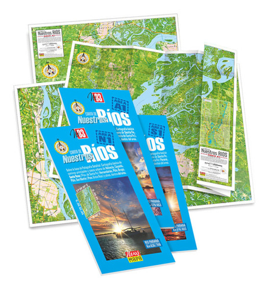
MAXI-MAPA Mapa Satelital Río Paraná
30-Day Money-Back Guarantee
Not satisfied? Return within 30 days for a full refund.
All tariffs & duties are already pre-paid and pre-cleared. No additional payments will be required on delivery.
- Shipping Time:
- Ships within 2-5 business days after your purchase. We will receive your product at our warehouse and carefully package it for international shipping.
- SKU:
- MLA911383563
- Condition:
- New
- Weight:
- 0.65 KGS
Description
Shop Mapa Satelital Río Paraná. Area A1 ( Km 579 / 653 ). Impreso and more Pósters at Latinafy.comDiscover the exquisite 'Mapa Satelital Río Paraná' from the stunning NUESTROS RIOS collection. This high-quality graphic map features detailed wetland charts of the Paraná River Basin, highlighted by its clear satellite imagery. Scaled at 1:75,000, the map elegantly showcases vital watercourses, urban centers, and terrains within the A1 area (Km 579 / 653). With its vibrant, full-color print on illustration paper, it's perfect for both practical navigation and decorative display. Elevate your exploration of this magnificent region with this professionally crafted map.Experience the natural beauty and geographical significance of the Paraná River with our expertly crafted 'Mapa Satelital Río Paraná'. This map is part of the esteemed NUESTROS RIOS collection, acclaimed for its high graphic quality and rich detail. It presents essential wetland cartography of the Central Litoral region (Km 636 / 770), with precise projections based on satellite photography from Landsat 7. The area captured, A1 (Km 579 / 653), showcases permanent waterways, streams, and lagoons, making it an invaluable resource for both enthusiasts and scholars alike.
The impressive map is created by utilizing cloud-free imagery, ensuring clear visibility of water levels and geographic features, finely tuned for optimal reader interpretation. Measuring 81 x 53.5 cm in an open format and folding down to a compact size of 23 x 12 cm, it’s designed for convenience and ease of use. The artwork is digitally processed with modified tones and contrasts enhancing its visual appeal. Printed in vibrant full color on satin-finished illustration paper, the map is not only practical but also serves as a stunning piece of decor for homes, offices, or educational settings.Usage ideas
This beautifully printed map is ideal for educational purposes, serving as a visual aid for geography lessons or nature studies. It's perfect for outdoor enthusiasts, including hikers and kayakers, who wish to navigate the Paraná River and its tributaries. As a striking piece of art, it can adorn any wall in your home or office, showcasing the intricate landscapes of the region. Additionally, this map makes a thoughtful gift for lovers of nature, exploration, or cartography.Frequently asked questionsWhat is the scale of the map?: The map is printed at a scale of 1:75,000, providing detailed representation.What materials is the map made from?: The map is made from high-quality satin-finished illustration paper.Can this map be useful for navigation?: Yes, it includes basic cartography of main roads and urban areas for practical navigation.- Brand: MAXI-MAPA- Item Condition: New- Model: MM-RÍOS-2en1-A1- Width: 81 cm- Height: 53 cm- Finish: Satin- Material: Illustration Paper- Custom Product: No- Includes Frame: No- Print Type: Full-Color Print- Theme: Maps of the Paraná RiverVendor listing title: Mapa Satelital Río Paraná. Area A1 ( Km 579 / 653 ). Impreso
View AllClose


